Land Use Committee unveils zoning plan
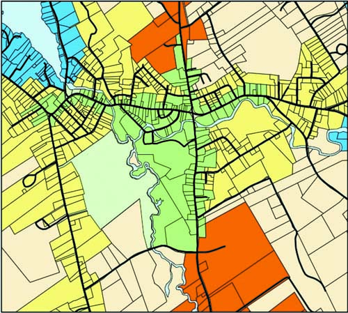
THE ADVENT OF ZONING — This draft Future Land Use Map for downtown Bridgton shows the Downtown Village Business Districts I and II, in green, extending along Main Street from Main Hill to the Kansas Road, and along Portland Road south to Willett Road, as well as a short distance north on Route 117. The yellow lots designate the Downtown Village Neighborhood; red, the Inner Corridor; and blue, the Lakeside Neighborhood. Lots shaded in pink designate the Rural Neighborhood. The map will be redone before the planned November vote so it will be easier to follow.
By Gail Geraghty
Staff Writer
Bridgton’s Land Use Committee made the rounds over the past week with its draft Land Use Ordinance, a zoning document that aims to protect the character of Bridgton while preserving the private property rights of its citizens. The ordinance, to be voted on this November, applies to the downtown and Route 302 south.
So far, judging from feedback given in separate meetings with the public, the Planning Board and Selectmen, it appears the committee has pretty much hit the mark. It’s no small achievement, considering the bitter contention that erupted five years ago, when McDonald’s came to town.
Questions remain, however, about some of the recommendations made by the committee, which was charged a year ago with implementing the Future Land Use section of the 2014 Comprehensive Plan. These include a proposal to create a Design Review Committee that would meet with property owners in the Downtown Village Business District, in advance of meeting with the Planning Board. Also being questioned are plans to allow five-story buildings in the Outer Corridor, as long as they’re set back at least 50 feet with buffering in front, and to restrict single-family home development in the Outer Corridor.
“Land use is difficult, because land has an owner,†said Planning Board member Dee Miller. “There’s always a danger to say you can’t use your property the way you want to.†She recalled the uproar and eventual rejection of zoning in Bridgton 20 or so years ago, when “you couldn’t even say the word†zoning without stirring up strong feelings. Since that time, Miller said, people have come to see the value of zoning as a way to protect their property. “People see it as a help, not a hindrance.â€
Planning Board Chairman Steve Collins praised the committee’s efforts, which will be fine-tuned in meetings and public hearings over the summer and fall. “This town should be really proud of your work,†said Collins, noting how the town failed to implement the 2004 Comprehensive Plan with regulations reflecting its goals. “There’s been a consistency of vision†this time around, said Collins. Early on, members agreed to focus on a hybridized version of form-based codes, which focus on setbacks and architectural appearance, instead of Euclidian zoning, where the focus is on uses that are allowed or not allowed.
Land Use Committee member Brian Thomas said he is proud of what the committee accomplished. “I think it’s awesome. It’s been a lot of work, a lot of arguments, but out of that has come a real solid document.
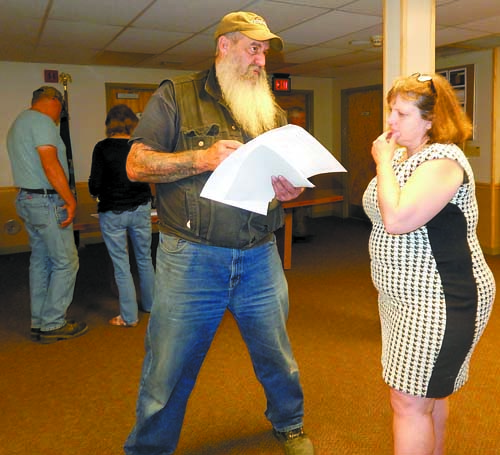
A WORK IN PROGRESS — Bridgton Selectman Glenn “Bear†Zaidman discusses the draft Land Use Ordinance with Anne Krieg, Director of Planning, Economic and Community Development, at a June 16 public information meeting.
The Districts
As proposed, new construction in the Downtown Village I District, along Main Street from Main Hill to Kansas Road, will be set back only six feet from the sidewalk, to preserve the eclectic New England charm of the downtown. In the Downtown Village II District, which extends from a short portion of Route 117 down Portland Road to Willett Road, the setback would be 15 feet. In the Inner Corridor, from Willett Road to Sandy Creek Road, setbacks of 25 feet will be the standard; and in the Outer Corridor, south to the Naples town line, the setback would be 50 feet.
“We tried to achieve a balance of development and open space, and we are not regulating any type of use,†said Committee Chairman Chuck Renneker. All existing structures will be grandfathered unless there’s a change of use. No residential uses will be allowed on the ground floor in the Downtown Village I District, and new construction will need to be two-story, to encourage mixed use.
The number and size of windows, or fenestration, would be regulated as well, and no downtown Main Street building would be allowed to exceed 120 feet of continuous building frontage.
“Renys would not be able to be built the way it is, by any means,†if the ordinance were in place when the business expanded, explained Thomas. Renys initially planned to have no windows facing Main Street, but compromised after Miller strongly objected.
“The lesson of Renys was taken to heart,†said Committee member Greg Watkins. Architectural recesses will be allowed, to break up the building and make it more interesting.
In the Village II District, buildings “will be allowed to breathe a little more,†said Committee member Bill O’Conner, who has led PowerPoint presentations to illustrate the changes. In the stretch of the Portland Road from Pondicherry Square to Maple Street, “the buildings are allowed to breathe a little more, and we’re all for maintaining that,†he said.
Committee member Ken Gibbs said the idea of creating a Design Review Committee gained hold after informal meetings were held with local developer Justin McIver, who built the Towanda’s and Firefly building and the new Chalmers building. McIver was “very amenable to the suggestions,†and agreed to build up to the sidewalk and adopt other changes in keeping with the character of Main Street. Gibbs said the committee would be only advisory and would apply only to new construction or renovation of 25% or more of the street-side façade of the existing building.
The design committee would schedule a public meeting within five days after an application is submitted, and draw up minutes for the Planning Board or code enforcement officer listing recommendations for suggested architectural and landscape design.
Renneker said developers would not be required to incorporate the suggestions in their plans, but the hope is that the design review process would serve as an encouragement to follow the town’s goals. “We hope to possibly change the developer’s mind, but as long as he meets the ordinance, he’s fine,†Renneker said.
Renneker said property along the Outer Corridor consists of mostly larger lots, and thus became the logical location for larger commercial and industrial development. “If General Motors wanted to build a plant, or a call center wanted to locate there, as long as (the building) is controlled by a buffer, I don’t have a problem with that,†he said. The same would apply to a big box store, he said.
Thomas noted that the Hannaford supermarket in Standish is so well-screened and set back from the highway that “you wouldn’t even know it was there.â€
Miller and fellow Planning Board member Debra Brusini, however, had a problem with the proposal to allow up to six stories of height. “Six stories seems like a lot,†Brusini said.
Renneker said the six-story allowance was “a recognition that we’re forcing larger developments there.†Initially the committee also said no to residential housing, but changed their mind after meeting with the Planning Board. As now proposed, the Outer Corridor would allow cluster residential development as long as there are sufficient setbacks in place.
“Bridgton’s a town that’s evolved over time, and has changed with the times,†said Renneker. “We’re in a period right now when we’re coming out of (the era) when things remained fairly static. As Portland moves toward us, Bridgton is going to evolve again. What we’re trying to do is control that growth to preserve that New England character.â€
The committee meets every Wednesday at 6 p.m. in the downstairs meeting room of the Bridgton Municipal Complex, and the public is encouraged to attend.