Greenprint produces powerful mapping tool
By Gail Geraghty
Staff Writer
For the first time ever, the seven towns of the Lake Region have come together to define the key attributes of their landscape that make it special to them.
And for the first time ever, the elements that make up the Lake Region’s 316-square-mile “Quality of Place†have been synthesized into powerful,

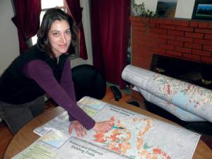
AN AWESOME MAPPING TOOL — Carrie Walia, executive director of the Loon Echo Land Trust, is very happy with the highly-detailed mapping tool that was created as the outcome of the year-and-a-half long Lake Region Greenprint process. She’s also pleased with the community-building that occurred among those who participated in identifying land conservation priorities for the seven-town region.
award-winning GIS Greenprinting software that cost $200,000 to develop, and now can be accessed by everyone online through the Internet.
Are you looking for that dream home near walking trails or water? Are you on a town committee looking to update your comprehensive plan? Are you a developer, looking for that ideal parcel of well-drained land in a designated growth zone?
Look no further. The Lake Region Community Greenprint has arrived.
The result of over a year’s work by a dedicated group of volunteers working with the Loon Echo Land Trust and the national Trust for Public Lands, the mapping tool is now complete, and can be accessed at http://tplgis.org/lakeregiongreenprint after obtaining a password from LELT. It was funded with $20,000 in contributions from the LELT towns of Bridgton, Casco, Denmark, Naples, Harrison, Sebago and Raymond, with the balance coming from TPL.
It’s a powerful piece of software, a mega-enhanced local version of Google Earth. With the click of a mouse on a tab, the user can have any number of attributes overlaid on standard GIS satellite imaging available in either street, terrain or aerial view.
Say you’re looking for a place with a view. Click and drag a box on the map in, say, Bridgton, to zoom in. Then click on the left-handed “data†tab and check out what the Greenprint Committee — after months of surveys, stakeholder meetings and public forums — identified about Bridgton that was special in terms of the final seven conservation goals: protect water resources, preserve plant and animal habitat, preserve working forests and farms, protect scenic views, protect and enhance existing trails, provide recreation and maintain small town character.
Place a checkmark beside the overall goal result of “protect scenic views†and, voila, the map is transformed by patches of shades of red showing areas where scenic views predominate. The darker the red, the better the view.
Now select from your many choices of overlay data. Click on “parcels†and the map is overlaid by tax map information. Click another overlay to show any local zoning ordinances affecting your scenic spot. Is it near trails? Cemeteries? A body of water? Are their any farmer’s markets or schools nearby?
Zoom in for detail on a single parcel. Zoom out for a more regional view. It’s all just a click away as users begin “digging down†to discover the hidden gems of the Lake Region.
TPL representative Jim Gooch unveiled the new software to a rapt audience of Greenprint Committee members at their last planning session held March 3. Everyone was understandably wowed, as they saw the power and potential of the software for use in regional and local planning.
“It was just really good to have people come back to see the results†of all their hard work, said LELT Executive Director Carrie Walia. From conservation committee members, planning board members to selectmen, she said, “People said to us, you just made my life a whole lot easier.†Walia said people were thankful that zoning, historic areas and tax map information can now be seen in relation with conservation priorities data such as preserving open space, and said, “What a useful tool to protect our small town character.â€
Most of the data is all publicly available in one form or another, but never before has it all been available in the same place, and all computerized, she said. “We just put it all in a package that says how the people want their community values to be best protected.â€
For people interested in developing passive recreational opportunities, the mapping tool is a goldmine, allowing them to see the region’s existing trail network for the first time. “It’s the first time we’ve gotten all motorized and non-motorized trails mapped,†including snowmobile, ATV, hiking and cross-country trails, Walia said.
It shows how well served each town and the region as a whole is in terms of access to water. All of the towns’ boat launches are identified and displayed as well.
The Greenprint was used to identify the region's priorities for the use, protection and sustainability of land and natural resources, a marriage of “soft†values with hard data. The maps are a culmination of the regional priorities which were developed through extensive stakeholder meetings, data collection, GIS analysis, and interviews with partners, advisers, and constituents.
All seven Lake Region towns granted $1 per resident to the project through town meeting appropriations or approval by selectmen. Additional funding for the project came from the Environmental Funders Network, Elmina B. Sewall Foundation, Horizon Foundation, Maine Community Foundation, Betterment Fund, and Davis Conservation Foundation.
The steering committee of around 20 people who remained engaged throughout the goal-setting process helped compile a list of 125 people from municipalities, non-profits, businesses, chambers of commerce, recreational clubs, lake associations and more who provided input that led to the final seven goals. There were also 400 random telephone interviews conducted.
Each of the seven goals are further broken down on the mapping tool into more detail. For example, under the highest priority goal — that of protecting water resources — the user can click on criteria reflecting that goal to identify areas where there are aquifers, headwaters, wellhead protection areas, areas subject to flooding, wetland buffers, water quality classifications and so on.
Similarly, under the goal of preserving plant and animal habitat, criteria can be selected to show areas where there are vernal pools or large unfragmented lands for wide-ranging species, as well as connectivity corridors for habitat.
Walia said the tool still has a few bugs that will need to be worked out. It doesn’t perform very well for users who have Internet Explorer for their web browser, for example; Firefox at this point works best.
The final Greenprint report will be coming out in around six weeks. After that, Walia said she and committee members will be going around to the seven towns to show the power of the software to boards and committees.
“One of the goals is to have a viable conservation committee in every town†that will be able to make use of the software, she said.
In the meantime, if anyone wants to take it for a test drive, they may call Walia at 647-4352 and she will give you a password.

