Freedom of the Hills: East Royce
This is a series of columns that highlight hikes and non-technical climbs in the Lakes Region and the White Mountains, to encourage readers to take a hike in the wonderful place we live here in Maine, during any season of the year.
By Allen Crabtree
Guest Writer
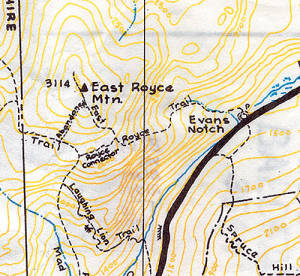
The trail up East Royce Mountain is challenging and steep in places, requiring rock hopping to cross Evans Brook and several other small streams in the first half-mile. The last brook crossing is at 1.0 mile and here the trail to East Royce diverges to the right.
In the spring, these streams will be running fairly full and the sound of water is never far from the hiker’s ears along the trail.
The left-hand trail at the trail junction is the Royce Connector that leads in 0.2 miles to the West Royce trail. The Maine-New Hampshire line runs between the two mountains — East Royce is in Maine and West Royce is in New Hampshire. The two mountains were named for Captain Vera Royce, a soldier in the French and Indian War. He received a 2,000-acre grant of land in the upper Saco River for his services. The mountains were labeled on Holland’s 1794 map of New Hampshire.
From the junction, the East Royce trail is quite steep requiring some rock scrambling to the eastern ledges at 1.3 miles from the trailhead. Here, there are good views of Speckled Mountain to the east. The marked trail ends here as well, but hike another 0.4 mile along a faintly marked beaten path from the eastern ledges to the true summit of East Royce (3,114 feet) and then to a broad open ledge for great views to the north and west.
The Denmark Mountain Hikers climbed this mountain last year and found the trail steep and challenging but the views well worthwhile. When on the top, a fast-moving thundercloud moved in and we made a hasty retreat to avoid being on the summit during a lightning storm. The heavy rains with the thunderstorm would have soaked us on the way down were it not for the rain gear we had in our packs. Be prepared for changes in the weather and keep an eye to the sky while on summits.
Hike facts

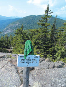
THIS IS THE TRAIL marker at the eastern ledges on East Royce where the marked trail ends, but there is a path from there to the true summit and northern ledge views.
East Royce Mountain is in Oxford County, Batchelder Grant, Evans Notch, Maine.
Difficulty: Moderate with steep sections and brook crossings.
Trail distance: One way, approximately 1.3 miles to the east ledges, 1.7 miles total to the northern ledges.
Hiking time: Round trip, 3 hours, 20 minutes to northern ledges and back.
Elevation: 3,070 feet at east ledges, 3,090 feet at northern ledges, summit 3,114 feet.
Vertical gain: 1,679 feet trailhead to northern ledges.
Coordinates: 44 degrees, 18’27’’ N; 71 degrees 0’20’’ W.
Directions: To the trailhead, about 23 miles north of Route 302 and Route 113 junction, north on Route 113 through Evans Notch to the height-of-land. Just north of the height-of-land, there is a White Mountain National Forest parking lot on the west side and the trailhead to East and West Royce. A WMNF parking permit is required ($3 daily or $20 for the year). The daily permit can be obtained at the parking lot.
What to bring: Good boots, rain gear, sunglasses, water and snacks, personal first aid kit, map and compass and cell phone. Let someone know your hiking plans before you leave!
Next time: Douglas Mountain in Sebago.


