Compromise saves one side of Causeway granite stones
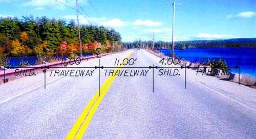
HALF A LOAF BETTER THAN NONE — As seen facing south toward Bridgton, this Photoshopped image of the Moose Pond Causeway shows a brown powder-coated guardrail on the Sabatis Island side, instead of the granite stones. But on the right, the “red granite guardians†have been preserved overlooking Moose Pond and Pleasant Mountain. The lettering depicts the plan to shift the centerline in order to create a 10-foot parking lane next to the stones, along with a four-foot shoulder and rumble strip. A five-foot shoulder would be created on the guardrail side. (MDOT image)
By Gail Geraghty
Staff Writer
State highway officials, called out by the town on their failure to follow federal historic preservation regulations on the Moose Pond Causeway, have agreed to let the granite stones stay in place on the Pleasant Mountain side of the Causeway.
A brown powder-coated guardrail with narrow posts will be erected on the other side, and the stones on that side will be removed and given to the town of Bridgton for placement elsewhere, possibly on Sabatis Island.
The revised design calls for a shifting of the centerline to allow for a 10-foot-wide parking lane and four-foot shoulder on the Pleasant Mountain side of the Causeway, where the stones will stay. That way, the southbound travel lane will be 14 feet away from the stones, and will be further enhanced for safety by a rumble strip that will be laid between the travel lane and the shoulder.
On the other side, a five-foot shoulder will separate the northbound travel lane from the guardrail, where there is a steeper slope to the water. Both travel ways will be 11 feet wide, which is still within federal regulations for highway corridors, said Colin Greenan, project engineer from the Maine Department of Transportation.
Greenan and representatives from the Federal Highway Administration met with Bridgton Selectmen Thursday and Town Manager Bob Peabody to brief them on the revised design.
The Causeway will be striped as a no passing zone, and a rumble strip will be laid between the southbound lane and its shoulder as a further safety measure. After the work is completed this summer, MDOT will monitor drivers’ speeds to see if any lowering of the 55-mile an hour speed limit should be considered in the future.
The compromise by the state highway safety engineers came after they learned what Greenan termed as “the complete picture of what the Causeway is to Bridgton,†at a December public meeting required under Section 106 of the National Historic Preservation Act. MDOT officials had passed over the required post-scoping review of the historic and architectural properties of the Causeway until their hand was forced by research done by Bridgton summer resident Dr. Bruce Clary. Selectmen then used Clary’s arguments to formally challenge the adequacy of the historic review under federal regulations and to require the state to hold a public meeting.
It was resident Kevin Raday, who lives close to the Causeway, who suggested at that meeting that the centerline be shifted to create unequal shoulder widths. Greenan said MDOT’s Engineering Council took that suggestion to heart when it met Jan. 14 to review the public record of concerns, which also included “quite a few†e-mails sent by residents after the meeting.
Cheryl Martin, assistant division administrator for the Federal Highway Administration, told selectmen at the Thursday meeting she was “very excited†to discuss the revised design, which she called a “Contact Sensitive Design.†FHA officials have been promoting contact sensitive designs for federal highways for years, because they are “flexible and sensitive to community values.â€
State highway officials present at the meeting said MDOT has used contact sensitive designs to address aesthetic considerations on other projects in Bar Harbor, Thomaston and Windham.
“We have listened, and we feel the revised design reflects (preservation of) the historic character and also safety concerns,†Greenan said. Also on hand at the meeting were Dr. Clary, Brian Thomas of the Moose Pond Association, Bill Warren, a summer resident of Moose Pond and Ned Allen, president of the Bridgton Historical Society.
Greenan said he realized many residents believed that lowering the speed limit would be enough on its own to ensure safety. But highway engineers felt it was necessary to create clear visual cues for slowing down, he said — thus the abnormally-wide shoulder on the southbound side.
“It’s the start of a process for lowering the speed limit,†Greenan said, noting, “This design does not meet all the engineering standards†but “we thought it was a good balance.†The stones that will stay will need to be reset and properly-aligned, and Greenan said care will be taken not to allow soil erosion into the pond, in response to a concern expressed by Thomas.
Selectmen agreed that if only one side could keep the granite stones, the southbound side made the most sense, since it has the most scenic view overlooking the pond and Pleasant Mountain. The 10-foot parking lane could also possibly be designated as a bike lane, although no decision has yet been made on that. Peabody said the northbound side, which will have the guardrail, ought to be clearly-designated as a “no parking†zone. Peabody’s comment sparked a discussion of Sabatis Island, located midway on the Causeway on the northbound side. Although the island is currently underutilized, selectmen noted that it is a local picnic and rest area with plenty of parking and a porta-potty.
“We took that over from the state†on a 100-year lease as a place for people to get off that highway,†said Selectman Bob McHatton. Martin said she will have her signage staff work with the town to decide how to best designate the availability of those facilities. Allen requested that a sign be erected on Sabatis Island noting the historic status of the property as the presumed home of Chief Sabatis, a Native American Indian Chief.
There was also discussion about how to designate where parking is, and is not, allowed. Peabody noted that the town is considering using available land at the West Bridgton Fire Station as a parking area for boat trailers after boats are put in at the boat landing.
Peabody called the redesign “a reasonable compromise†and Selectman Ken Murphy thanked the state and federal highway officials for listening to the local concerns of the people. Warren told them he realized “I came down pretty hard on you†with his letter espousing the importance of “the red granite guardians†on the Causeway.
Selectman Chairman Bernie King said he was glad the redesign keeps the southbound side visually unchanged.
“Frankly, I didn’t expect the compromise,†King said. “I thought it would be little or none.â€